Stomping Grounds | 1223 W 34th Street

CLICK ON THE GRAPHIC ABOVE FOR GOOGLE'S INTERACTIVE MAP.
CLICK ON THE IMAGE TO ENLARGE.
Building:
28,00 square feet
Land:
3 acers
Parking: 209 spaces
Traffic Count: 11,000 cars per day
Demographics:
One mile – 14,237 population, $113,070 average household income
Three mile – 130,078 population, $82,9852 average household income
Space Available:
94% occupied
Current Tenants:
Sonoma Wine Bar, Luloo’s Day & Night. Himari, Rooster and Rice, Fat Cat Creamery, Pho Fix, Paint Nail Bar, Bollo Pizza, La Mex, Tulum Wellness Spa, Kid Create, Flowe, Her and Rease, Becca Cakes, Threadfare
Notes:
Yale & 11th | 1102 Yale Street

CLICK ON THE GRAPHIC ABOVE FOR GOOGLE'S INTERACTIVE MAP.
CLICK ON THE IMAGE TO ENLARGE.
Building:
10,501 square feet
Land:
32,000 square feet
Parking: 45 spaces
Traffic Count: 35,000 cars per day
Demographics:
One mile – 19,055 population, $92,164 average household income
Three miles – 143, 196 population, $87,262 average household income
Space Available:
100% occupied
Current Tenants:
Anytime Fitness, Lola, Sharkey’s Cuts for Kids
Notes:
Originally built in 1932 as a grocery store, the latest remodel was completed in 2008. The restoration was awarded The Good Brick Award by the City of Houston in 2009. This center is located on the hard corner of Yale and 11th Street, one of the highest traffic counts in The Houston Heights and one of only two intersections where two four-lane roads converge. 11th Street is one of the few east/west thoroughfares that carry traffic all the way through The Houston Heights from Hempstead Highway to I-45. Yale has new, improved entrance and exit ramps allowing easy access both east and west
on I-10.
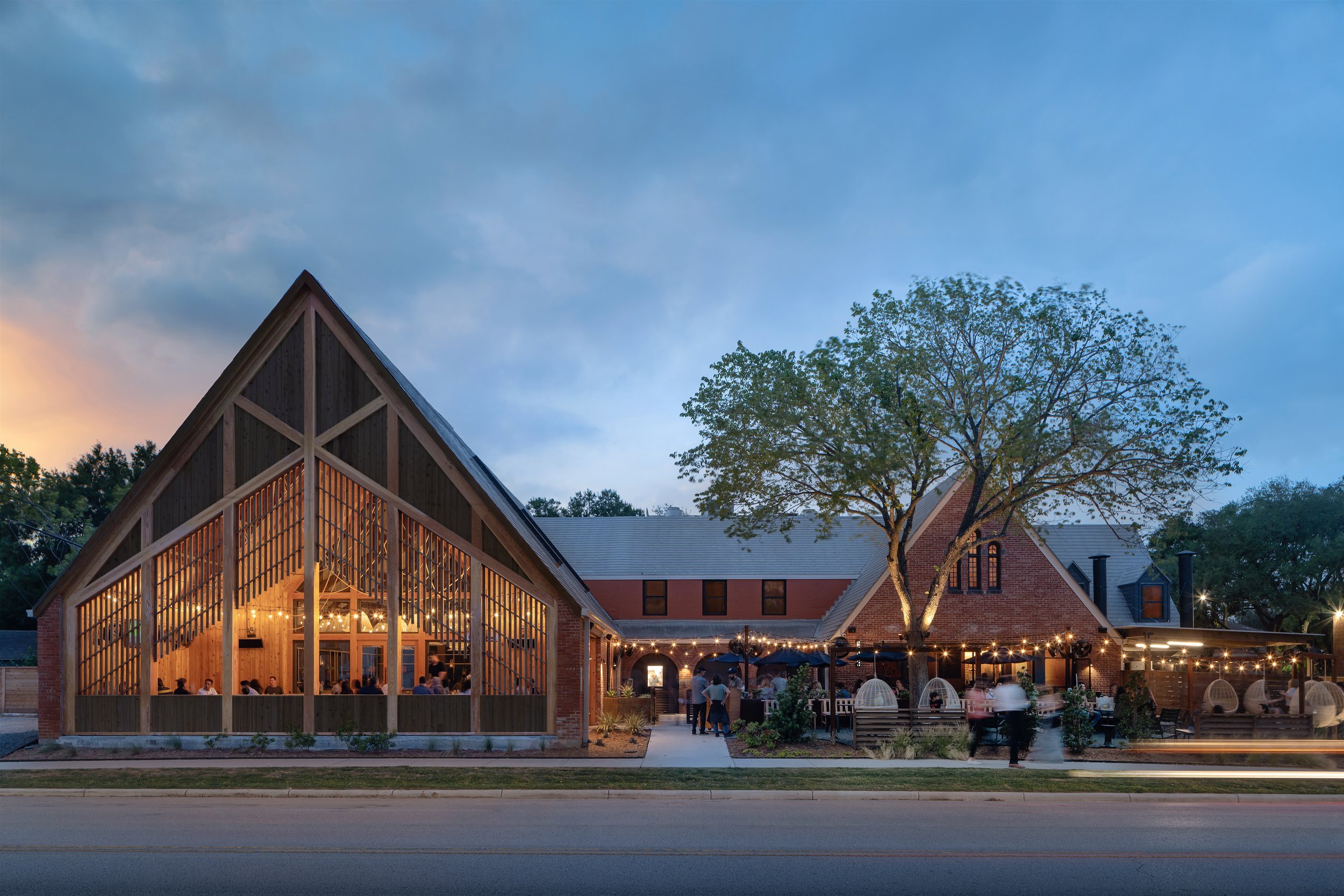
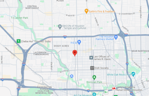
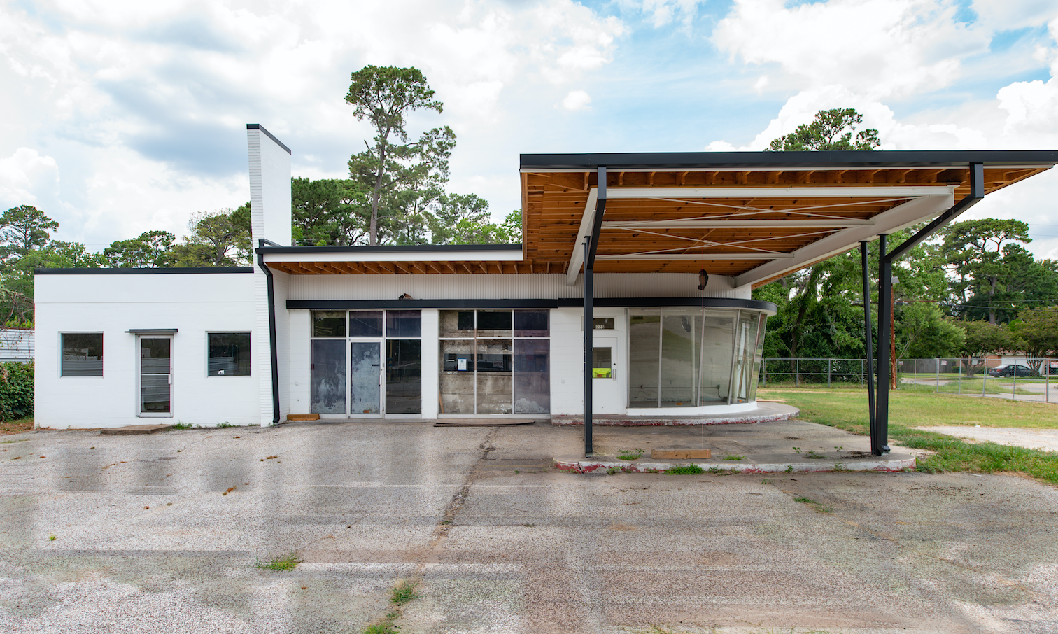
518 W11th | 518 W 11th Street

CLICK ON THE GRAPHIC ABOVE FOR GOOGLE'S INTERACTIVE MAP.

CLICK ON THE IMAGE ABOVE FOR A COMPLETE .PDF FLYER.
Building:
5,280 square feet
Land:
13,119 square feet
Parking: 28 spaces
Traffic count: 10,000 cars per day
Demographics:
One mile – 19,574 population, $99,605 average household income
Three miles – 147,644 population, $107,388 average household income
Space Available:
100% occupied
Current Tenants:
Allergy & ENT Associates, Al Quick Stop, Hando, The Bearded Baker
Notes:
Freebirds World Burrito | 700 Earl Rudder Freeway

CLICK ON THE GRAPHIC ABOVE FOR GOOGLE'S INTERACTIVE MAP.
CLICK ON THE IMAGE TO ENLARGE.
Building:
25,000 square feet
Land:
30,000 square feet
Parking: 35 spaces
Traffic Count: 70,000 cars per day
Demographics:
One mile – 6,594 population, $61,442 average Household income,
Three miles – 74.416 population, $49,280 average household income,
Space Available:
100% occupied
Current Tenants:
Freebirds World Burrito
Notes:
Commissioned by the president of Freebirds, we completed this build to suit in 2006.
19th & Shepherd | 632 WEST 19TH

CLICK ON THE GRAPHIC ABOVE FOR GOOGLE'S INTERACTIVE MAP.
CLICK ON THE IMAGE TO ENLARGE.
Building:
2,000 square feet
Land:
13,100 square feet
Parking: 30 spaces
Traffic count: 35,000 cars per day
Demographics:
One mile – 16,753 population, $89,904 average Household income
Three miles – 131,151 population, $82,394 average household income
Space Available:
100% occupied
Current Tenants:
Squable
Notes:
Second generation freestanding restaurant building with 30 on-site parking space previously occupied by Pie in the Sky and Table 19. Being 100’ feet from the Southeast corner of 19th Street and North Shepherd, this building is at the front door of the historic 19th Street shopping district. It is amongst the largest cluster of retailers in The Houston Heights. Tenant will benefit from quick and easy access to Garden Oaks, Oak Forest, Timbergrove and Lazy Brook.
19TH & SHEPHERD — PHASE I | 1901 N SHEPHERD DR.

CLICK ON THE GRAPHIC ABOVE FOR GOOGLE'S INTERACTIVE MAP.
PHASE I BUILDING:
8,000 SQUARE FEET
LAND:
32,750 SQUARE FEET
Parking: 65 spaces
Traffic Count: 35,000 cars per day
DEMOGRAPHICS:
One mile – 16,753 population, $89,904 average Household income,
Three miles – 131,151 population, $82,394 average household income,
SPACE AVAILABLE:
100% occupied
CLICK ON THE IMAGE TO ENLARGE.
CURRENT TENANTS:
Smoothie King, Finch Properties, Gold Tooth Tony’s, Amy’s Ice Cream, Houston Hair Salon and Ka Sushi
NOTES:
On the hard corner of Shepherd and 19th Street, this center is the front door to the historic 19th Street shopping district. It is amongst the largest cluster of retailers in The Houston Heights. Located between Shepherd and Durham, tenants benefit from quick and easy access to Garden Oaks, Oak Forest, Timbergrove and Lazy Brook.
19TH & SHEPHERD — PHASE II | 721 W. 19th

CLICK ON THE GRAPHIC ABOVE FOR GOOGLE'S INTERACTIVE MAP.

BUILDING:
4,475 square feet
Land:
13,000 square feet
Parking: 20 spaces
Traffic Count:
DEMOGRAPHICS:
One mile – 16,753 population, $89,904 average Household income,
Three miles – 131,151 population, $82,394 average household income,
SPACE AVAILABLE:
100% occupied
CURRENT TENANTS:
Benjamin Moore Paint, Tarka Indian Kitchen
NOTES:
WHITE OAK & STUDEWOOD | 602 STUDEWOOD ST.

CLICK ON THE GRAPHIC ABOVE FOR GOOGLE'S INTERACTIVE MAP.
BUILDING:
5,000 SQUARE FEET
Land:
28,000 square feet
Parking: 55 spaces
Traffic Count: 30,000 cars per day
DEMOGRAPHICS:
One mile – 8,118 population, $94,200 average household income, 5,828 daytime population
Three miles – 83, 271 population, $66,382 average household income, 30,810 daytime population
SPACE AVAILABLE:
100% occupied
CURRENT TENANTS:
Mapojeong
NOTES:
A portion of the current building was originally built in 1929. The latest remodel will be completed in 2013. This restaurant is located in the “wet” portion of The Houston Heights, on the hard corner of Studewood and White Oak. It is a part of the new White Oak entertainment district – eleven restaurants and bars operating within two blocks. This stretch of White Oak is within the highest concentration of wealth in the trade area. New access ramps onto I-10 provide excellent access heading both east and west. Will be completed in 2014.
HEIGHTS BLVD. & 11TH | 1101 HEIGHTS BOULEVARD

CLICK ON THE GRAPHIC ABOVE FOR GOOGLE'S INTERACTIVE MAP.

CLICK ON THE IMAGE ABOVE FOR A COMPLETE .PDF FLYER.
BUILDING:
3,080 SQUARE FEET
Land:
13,500 square feet
Parking: 22 spaces
Traffic Count: 35,000 cars per day
DEMOGRAPHICS:
One mile – 19,055 population, $92,164 average Household income
Three miles – 143,196 population, $87,262 average household income
SPACE AVAILABLE:
100% occupied
CURRENT TENANTS:
MedSpring Urgent Care
NOTES:
Located in the Historic Houston Heights District with Heights Blvd. frontage.
11TH & STUDEWOOD | 1123 E. 11TH ST.

CLICK ON THE GRAPHIC ABOVE FOR GOOGLE'S INTERACTIVE MAP.
CLICK ON THE IMAGE TO ENLARGE.
CURRENT TENANTS:
Bicycle Speed Shop
NOTES:
Originally built in 1925 as a pool hall, the latest remodel completed in 2013. This historic property is located in an “old town” cluster of preserved buildings in the northeast quadrant of 11th Street and Studewood. The building is surrounded by multiple restaurants and situated between the prestigious Norhill and Woodland Heights neighborhoods.
Building:
1,700 square feet
Land:
5,000 square feet
Parking: 7 spaces
Traffic Count: 15,000 cars per day
DEMOGRAPHICS:
One mile – 20,931 population, $91,928 average household income
Three miles – 156,159 population, $84,091 average household income
SPACE AVAILABLE:
100% occupied
11TH ST/PECORE AT NORTH MAIN | 3701 N. MAIN

CLICK ON THE GRAPHIC ABOVE FOR GOOGLE'S INTERACTIVE MAP.

Building:
1285 Square feet
Land:
8,375 Square feet
Parking: 13 spaces
Traffic Count: 11,000 cars per day
DEMOGRAPHICS:
One mile – 22,182 population, $158,102 average household income
Three miles – 199,228 population, $130,894 average household income
SPACE AVAILABLE:
100% occupied
CURRENT TENANTS:
Cantina Barba
NOTES:
Durham Triangle at 16th Street | 1603 N. Durham Dr.
CLICK ON THE GRAPHIC ABOVE FOR GOOGLE'S INTERACTIVE MAP.

Building:
1.156 square feet
Land:
7,766 square feet
Parking:
Traffic Count: 18,500 cars per day
DEMOGRAPHICS:
One mile – 6,429 population, $89,872 average household income
Three miles – 53,029 population, $83,701 average household income
SPACE AVAILABLE:
100% occupied
CURRENT TENANTS:
Mico’s Hot Chicken
NOTES:
1001 W 11th | 1001 W 11th

CLICK ON THE GRAPHIC ABOVE FOR GOOGLE'S INTERACTIVE MAP.
Building:
6,940 square feet
Land:
25,000 square feet
Parking: 40 spaces
Traffic Count: 11,000 cars per day
DEMOGRAPHICS:
One mile – 21,463 population, $175,531 average household income
Three miles –82,175 population, $173,263 average household income
SPACE AVAILABLE:
100% occupied
CURRENT TENANTS:
Loro
NOTES:
309 Lockwood | 309 Lockwood Dr

CLICK ON THE GRAPHIC ABOVE FOR GOOGLE'S INTERACTIVE MAP.

Building:
1,170 square fee
Land:
18,634 square feet
Parking: 17 spaces
Traffic Count: 27,000 cars per day
DEMOGRAPHICS:
One mile – 15,539 population, $65,084 average household income
Three miles –144,278 population, $83,369 average household income
SPACE AVAILABLE:
0% occupied
CURRENT TENANTS:
Available
NOTES:
This ground lease opportunity for this second generation restaurant is situated East of Downtown in the popular East End Revitalized area. Plans have been approved to renovate the existing structure located on Lockwood Drive adjacent to Harrisburg Hike & Bike Trail. See the conceptual renderings for Mo's Place, a place to eat, drink and chill. Enjoy the large green space outdoors complete with picnic tables and a stage for live entertainment.
W 11th & Ashland | 1045 Ashland Dr

CLICK ON THE GRAPHIC ABOVE FOR GOOGLE'S INTERACTIVE MAP.

Building:
2,621 square feet
Land:
13,156 square feet
Parking: 22 parking spaces
Traffic Count: 21,000 cars per day
DEMOGRAPHICS:
One mile – 21,000 population, $176,000 average household income
Three miles –166,000 population, $155,000 average household income
SPACE AVAILABLE:
0% occupied
CURRENT TENANTS:
Available
NOTES:
Shepherd & 34th | 3210 N Shepherd Dr

CLICK ON THE GRAPHIC ABOVE FOR GOOGLE'S INTERACTIVE MAP.

Building:
1,842 square feet
Land:
14,810 square feet
Parking: 14 parking spaces
Traffic Count: 16,000 cars per day
DEMOGRAPHICS:
One mile – 14,246 population, $96,000 average household income
Three miles –154,456 population, $87,440 average household income
SPACE AVAILABLE:
100% occupied
CURRENT TENANTS:
Common Bond
NOTES:
Westview & Witte | 1223 Witte

CLICK ON THE GRAPHIC ABOVE FOR GOOGLE'S INTERACTIVE MAP.
Building:
2,061 square feet
Land:
15,440 square feet
Parking: 21 parking spaces
Traffic Count: 5,000 cars per day
DEMOGRAPHICS:
One mile – 19,000 population. $79,000 average household income
Three miles –134,000 population $114,000 average household income
SPACE AVAILABLE:
100% occupied
CURRENT TENANTS:
N/A
NOTES:
Westview & Witte | 9936 Westview

CLICK ON THE GRAPHIC ABOVE FOR GOOGLE'S INTERACTIVE MAP.

Building:
2,579 square feet
Land:
29,774 square feet
Parking: 30 parking spaces
Traffic Count: 6,786 cars per day
DEMOGRAPHICS:
One mile – 19,000 population. $79,000 average household income
Three miles –134,000 population $114,000 average household income
SPACE AVAILABLE:
100% occupied
CURRENT TENANTS:
The Blue Lagoon